

Getting professional help with a boundary dispute
|
|
Getting professional help with a boundary dispute1. What your Boundary Surveyor cannot do Many clients have false expectations of what their boundary surveyor can achieve for them. These expectations arise out of a lack of knowledge, which is unsurprising given that very few landowners and homeowners have any education in land law. Many landowners think that there must be some government-backed agency that has the authority to declare exactly where a property boundary is supposed to be. They soon discover that Land Registry is not that agency. They then turn to a surveyor who offers advice in boundary disputes in the expectation that the surveyor will write to the neighbouring landowner to tell that neighbour where the boundary is and what that neighbour should do to set matters right. Unfortunately, your surveyor is not registered by the government, has no royal warrant, has no power of arrest, and is not entitled to tell your neighbour what is right and what is wrong concerning boundaries. The neighbour will be as unimpressed with a letter from your surveyor as they would be with a letter from your solicitor. Your neighbour will not do what your surveyor asks. The matter will not be resolved.
2. Understanding the framework surrounding boundaries 2.a. Who creates and describes boundaries? There is no government agency with responsibility for deciding where property boundaries should be. A boundary is created when a landowner divides his land in order to sell the divided off part of it. There is no legal requirement for a vendor to consult a government agency when deciding along what line to divide his or her land prior to selling part of it and, indeed, there is no government agency to turn to for such advice. The landowner, or an agent of his such as his conveyancing solicitor, is usually responsible for describing the boundary. That boundary description is found in the deed accompanying the first sale of the land. For unregistered land this would be a conveyance; if the parent parcel of land was already registered prior to its division then the deed would be a "transfer of part". The description usually takes the form of words in the "parcels clause" and of an accompanying plan. 2.b. Land Registry's role Unfortunately, the deed plan that accompanies division of a vendor's land is nearly always insufficiently accurate to allow for an accurate determination of the boundary's position, and may be based upon out-of-date information as to what is on the ground. The words in the parcels clause of the deed always neglect to mention how the boundary is physically marked upon the ground. These two facts render ambiguous almost all boundary descriptions. Land Registry was established in 1862 under the Land Registry Act 1862. The Act describes itself as "An Act to facilitate the Proof of Title to, and the Conveyance of, Real Estates." Its remit was initially limited to England but later extended to include Wales. Section 10 of the 1862 Act sets out that "The Identity of the Lands with the Parcels or Descriptions contained in the Title Deeds shall be fully established, and the Registrar shall have Power by such Inquiries as he shall think fit to ascertain the Accuracy of the Description and the Quantities and Boundaries of the Lands". Section 17 recognised that boundary descriptions had the potential for ambiguity and set out that "If in making up, or afterwards continuing, such Record of Title as aforesaid, any Question shall arise as to the true Construction or legal Validity or Effect of any Deed, Instrument, or Will, or as to the Persons entitled, or the Extent or Nature of the Estate, Right, or Interest, Power or Authority of any Person or Class of Persons, or the Mode in which any Entry ought to be made in the Record of Title, or any doubtful or uncertain Right or Interest stated or dealt with by the Registrar, it shall be competent for the Registrar, or for any of the Parties interested, to refer the same to a Judge of the Court of Chancery". The truth of the matter was that most applications for registration had to be referred to the Court of Chancery for a decision as to the true position of the boundary. Applications for registration met with difficulties, delays and expense. Land registration was getting a bad name. The Land Transfer Act 1875 sought to avoid referring every registration application to court by giving the Registrar powers to hear objections. It also removed the need to ascertain boundaries to the nearest inch, effectively inventing the "general boundaries" that currently blight the system. The Land Transfer Act 1897 introduced compulsory registration of title, and yet in 2019 there remains a significant minority of unregistered land. The Act also prescribed that "the Ordnance Survey map, on the largest scale published, shall be the basis of all registered descriptions of land". This is a curious development, given that the Ordnance Survey Act 1841 prevents Ordnance Survey maps from showing property boundaries and from having any effect on anyone's legal interests in land. Moreover, the Ordnance Survey maps are not sufficiently accurate to show the exact positions of the physical features represented by the lines on those maps.
3. Boundary disputes are inevitable A great many boundary descriptions found in deeds (conveyances and transfers of part) are based upon Ordnance Survey maps. These maps offer an uncertain position for the physical features shown on the maps, and the deeds offer no evidence of the relationship between the property boundary and the physical feature shown on the map. Land Registry relies, as the basis for their descriptions of the extents of registered land, on Ordnance Survey maps that by law do not show property boundaries. Worse still, those same Ordnance Survey maps are not sufficiently accurate to show with exactitude the positions of the physical features that they portray. In other words, Land Registry does not know exactly where any boundary of registered land is to be found. In the case of many properties, once title has been registered the original deeds are destroyed. In these cases, the only boundary description available is Land Registry's "general boundary". It is safe to say that no vendor offers an adequate description of the land that the purchaser is buying, and no conveyance nor any transfer of part comes with a guarantee as to the position of the boundaries of the land being sold. The preceding four paragraphs are not the description of a model land registration system. The preceding four paragraphs describe an environment in which boundary disputes will inevitably flourish.
4. What, realistically, can your boundary surveyor do for you? 4a. Litigation support Traditionally, the surveyor's role in boundary disputes is to assist a court by interpreting onto an accurate plan the position of the "paper title boundary" (the boundary described in the deed that divided the vendor's land), and to support that interpretation with an expert report and with oral evidence given in court. The leading boundary surveyors are able to offer early neutral evaluation of the technical issues in a boundary dispute (it requires a barrister to make an early neutral evaluation of the legal arguments). The purpose of early neutral evaluation is to encourage the parties to jointly commission the evaluation so that the dispute starts on a level playing field of shared knowledge and an impartial assessment of which factual evidence (or legal argument if the evaluation is made by a barrister) is likely to carry weight and influence a judge. The evaluation would also suggest an appropriate alternative dispute resolution method for settling the dispute out of court. 4.b. Alternative dispute resolution methods Your boundary surveyor may be able to assist in resolving the boundary dispute in some of the following ways. Some surveyors have trained as arbitrators who will be asked to make a decision as to where the boundary is. The process may be treated as a desk exercise, or as an informal hearing in front of the arbitrator. Some surveyors have trained as mediators who will facilitate a negotiation between the parties in which all contentious issues are discussed and settled by negotiation. This may result either in clarification of the exact position of the boundary or it may result in the position of the boundary being moved in order to reach a settlement of the dispute. In the latter case the mediator will make the arrangements needed to deal with the movement of the boundary. Some surveyors offer expert determination, in which the disputing parties agree to leave the legally binding decision as to the true position of the boundary to the expert they have appointed. The above alternative dispute resolution methods all rely upon the parties agreeing with each other that they will submit to the particular method. In this, they differ from litigation, which is usually initiated by the unilateral action of one of the parties. 4.c. Amicable settlement Litigation has a reputation for being unduly bitter, expensive and time-consuming. ADR (alternative disputes resolution) is undoubtedly considerably quicker than litigation, with a corresponding reduction in expense and time consumed by the dispute. It follows that an amicable settlement of a boundary dispute is much preferable. It can only be achieved if both parties are willing to engage with each other without resorting to animosity, and with both parties being willing to take friendly and impartial advice from an experienced expert in the matters at issue. |
| Return to Top of Page |
What kind of surveyor?
Finding the right surveyor to do most specialist surveying tasks can be difficult. There is no surveying equivalent to the NHS referral system operated by general practitioners, alias family doctors. So you may feel confused as you are left alone to identify the right kind of surveyor for the task that you require to be done.
For a start, there are twenty different designations that chartered surveyors may use, not including "chartered surveyor" itself, ranging from "Chartered Arts & Antiques Surveyors" to "Chartered Valuations Surveyors & Estate Agents". But amongst this list you will not find a chartered boundary surveyor. This is where it gets confusing.
The Royal Institution of Chartered Surveyors (RICS) allows its members to offer services in any specialist field in which they believe themselves to be competent. One specialist field is Boundary Demarcation and Disputes. But before you charge off and find the nearest chartered surveyor offering services in Boundary Demarcation and Disputes you need to be aware of a few things.
Firstly, there are seven routes for becoming qualified as a chartered surveyor, and there is no common core subject area that all seven qualification routes are obliged to teach. So if someone who calls himself either a "general practice" surveyor or a Chartered Valuation Surveyor tells you he has been trained in land surveying then you need to ask him some searching questions about that land surveying training. His qualifying course may have included one week of measuring with a tape measure, but such brief land surveying training bears no comparison with the training given to a Chartered Land Surveyor who spends more than a year on an MSc level course.
Then again, not all land surveying courses include a module on land law. So not all Chartered Land Surveyors are suited to Boundary Demarcation and Disputes. And yet, even if someone is a Chartered Valuation Surveyor it doesn't automatically mean that he is inappropriate to Boundary Demarcation and Disputes. I have come across more than one Chartered Valuation Surveyor who is good at boundary disputes, even though he may have to sub-contract the land surveying portions of the work to another company.
Many Chartered Building Surveyors offer Party Wall Advice. Party walls, by definition, stand upon boundaries. So some Chartered Building Surveyors develop an understanding of boundary demarcation and disputes. But be careful: party walls advice is all about building structures and may have a lot to do with preventing or resolving disputes between neighbours, but it has little or nothing to do with boundary demarcation. So if you use a Chartered Building Surveyor for a boundary dispute then do make sure that he has the additional skills needed for boundary demarcation that are not normally exhibited by someone advising on party walls.
Chartered Surveyors who operate in "rural practice" are often very good all rounders, and a number of these may have sufficient skills for boundary demarcation and disputes, even if they have to subcontract the land surveying aspects.
Guidance on locating a suitable surveyor is given at the foot of this page. Before proceeding to that, you first need to understand and identify the needs that your chosen surveyor is going to have to address.
| Return to Top of Page |
Surveyor's skills
There is a range of key surveying skills that are relevant to boundary disputes, but the range of skills required to accomplish a task varies with the nature of the task.
For example, if the task is essentially a mapping task, such as:
- creating a transfer plan because you want to sell half of your rear garden;
- making a plan to record a boundary agreement or a determined boundary that has been amicably agreed between you and your neighbour;
then you will need a land surveyor who has knowledge of Land Registry's requirements for these kinds of plan.
For example, if you want only advice on where your boundaries are then you will need a surveyor, not necessarily a land surveyor, who
- understands that Land Registry title plans show only the general position and not the exact position of the boundaries;
- understands map accuracies and understands that it is unwise to try to scale distances to a precision of 0.5m or less from an Ordnance Survey map;
- has an ability and willingness to check the accuracy of OS maps, transfer plans and conveyance plans, even if with only a tape measure;
- can interpret maps correctly;
- has some understanding of land law:
but be warned that many surveyors, even land surveyors, can be found wanting on several of the skills in the above list. So make sure that your surveyor is a specialist in boundary demarcation and disputes. Then ask him what percentage of his workload is taken up with boundary demarcation and disputes, and if the answer is less than 25% then he probably has insufficient experience.
For example, if you need a thorough investigation of a disputed boundary and an expert report that can be used in a court case then you will need a chartered land surveyor specialising in boundary demarcation and disputes who has all of the skills in the above list and can also offer:
- land measurement and map drawing,
- the ability to overlay old plans with accurate survey,
- the ability to reconcile conveyance dimensions with accurate survey,
- a knowledge of historical land surveying technology, methods and accuracy,
- air photo interpretation,
and can offer these investigative skills:
- observation skills and an eye for fine detail,
- open mindedness,
- deductive reasoning,
- an ability to derive significance from placing events in chronological order,
- an ability to corroborate or eliminate claimed "facts" by collating and comparing different pieces of evidence.
In order to put his arguments convincingly in an expert report the surveyor must have good presentation skills both with the written word and with the ability to produce clear, uncluttered drawings.
Should your case go to court then your surveyor will need good oral presentation skills and the ability to think on his feet in order to give oral evidence in the witness box.
Before asking a surveyor to write an expert report, you should be aware that the Civil Procedure Rules, Part 35 (governing the work of expert witnesses) requires that an expert witness' duty to assist the court on matters within his expertise overrides any obligation to the person from whom he has received instructions or by whom he is paid. So be warned that it is not the expert's job to make a better case for you than the evidence supports, and a good expert will be prepared to tell you when the evidence is running against you.
| Return to Top of Page |
A property barrister's view
Nicholas Isaac of Tanfield Chambers describes in two short articles what he
would expect to find in an expert report on the subject of a boundary that is in
dispute:
Resolving boundary disputes - Lesson 4: The measured site survey
Resolving boundary disputes - Lesson 5: The expert's report
It should go without saying that getting the best boundary demarcation and disputes expert is much more important than getting the most local one. You will undoubtedly save a few hundred pounds by using a more local expert. But if your local expert is not much good at analysing the evidence, writing a convincing report, and explaining himself in the witness box, then you must consider whether those few hundred pounds saved are worth the increased risk that you might lose the case and be ordered to pay your neighbour's costs.
| Return to Top of Page |
Finding the surveyor
| 1. If you need advice about a
boundary or a right of way then you may wish to get in touch with the author of
this web site: click on one of the logos below for contact details. |
|
|
|
|
|
|
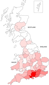
| Counties in which he has worked in the past (between 2000 and 2013) are indicated on the map at right, the darker the tint, the more clients in that county. | ||
| 2. If you know that you need a
chartered surveyor but don't know which kind of surveyor you need, then telephone
the RICS Consumer Helpline on 02476 868 555 to outline
your problem and they will put you in touch with someone who can help. |
|
| 3. If you want to search online for a chartered surveyor in England, Wales or Scotland who has expertise in boundaries then the place to look is the online directory of chartered surveyors at www.ricsfirms.com/helplines/boundary-disputes/. | |
 Scroll down the ricsfirms.com/helplines/boundary-disputes/ page to see a list of survey firms arranged alphabetically by firm's name, followed by the town in which the firm is located. On 10 May 2022 there were 71 firms listed as having expertise in boundaries. |
|
| 4. It is, of course, a wise precaution not to instruct the first expert witness you locate. So, if you have identified a number of candidates, how do you choose between them?
|
| Return to Top of Page |