


It may come as a shock to the reader to learn that:
the exact positions of the boundaries of the land in that title.
Land
Registry's web site admits:
If you live in England or Wales, there's usually no record of:
This page explains the limitations of title plans.
For an explanation of the limitations of the Ordnance Survey maps on which Land
Registry's title plans are based, see
Using
Ordnance Survey maps.
Land Registry does not define property boundaries. Land Registry compiles and maintains a register of titles to land. The boundaries of each registered title were created by the landowner who divided his land in order to sell off a part of it. There are no laws or regulations governing the standards by which the boundaries are described by the seller/vendor/transferor or by his or her conveyancing solicitor or estate agent: and it is usually not known which of these people made the original description of the boundary.
FREQUENTLY ASKED QUESTION |
||
| Can I use the title plan to work out the exact
position of my boundary by scaling the distance from the boundary to the side of
my house? Firstly, the title plan is based upon the Ordnance Survey map, and as to the accuracy limitations of the Ordnance Survey map, one need only consult the table of relative accuracy of Ordnance Survey maps to appreciate how dangerous it might be to scale a distance from a title plan. Moreover, there is a warning in red text at the foot of the title plan that states: This title plan shows the general position, not the exact line, of the boundaries. It may be subject to distortions in scale. Measurements scaled from this plan may not match measurements between the same points on the ground. |
||
To reinforce the message, I will now quote the thrice repeated banner in Nicholoas Isaac's article Resolving boundary disputes - Lesson 1: Boundaries and Land Registry plans, which reads:
where the boundary is.
| Return to Top of Page |
Title Plans show only general boundaries
By law, Land Registry is required by Section 60 of the Land Registration Act 2002 to show only the general positions of the boundaries of the land in a registered title.
A Title Plan is a map produced by Land Registry to record the general position of the boundaries of a registered title in accordance with Rule 5 of The Land Registration Rules 2003. This states:
| Contents of the property register 5 Except where otherwise permitted, the property register of a registered estate must contain- (a) a description of the registered estate which in the case of a registered estate in land, must refer to a plan based on the Ordnance Survey map and known as the title plan; |
Ordnance Survey maps are prevented by Section 12 of the Ordnance Survey Act 1841 from showing property boundaries. There are also issues concerning the accuracy of Ordnance Survey maps.
The mention of the general position of the boundary
and the implications of using Ordnance Survey maps ought to be enough to alert
land owners and their professional and legal advisers to the limitations of the title plan.
In case it is not, Land Registry prints a warning in red text at the foot of every
title plan that it issues. This says:
This title plan shows the general position, not the exact
line, of the boundaries. It may be subject to distortions in scale. Measurements
scaled from this plan may not match measurements between the same points on the
ground.
It is of the utmost importance to understand that Title Plans do not show the exact (i.e. the precise) position of the boundaries of the land in the title. In an effort to explain this, a joint statement by Land Registry and Ordnance Survey was prepared in about 2009 and revised in 2014.
What does a title plan show?
Two (fictitious) examples of title plans, showing how they relate to their corresponding title registers, are given in Land Registry Practice Guide 40, supplement 5: Land Registry Plans: title plan. You will also find at Appendix 1 to that supplement a diagram explaining the scheme of colours that Land Registry employs in compiling a title plan.
| Return to Top of Page |
Understanding the title plan
1. Land Registry is NOT responsible for deciding where to place the boundaries that divide individual parcels of land. That responsibility falls to the owner who divided the land into the present parcels.
2. The description of the boundary given in the title deeds produced by or for the vendor is usually sadly wanting: see Boundary Descriptions, and Conveyance Deeds and Plans. It is the poor standards of boundary descriptions in conveyances that forced Land Registry to adopt the principle of recording only the "general boundary" as early as 1875. See the article 100 years of OS/LR Co-operation.
3. It is Land Registry's duty to examine the title deeds submitted to them at first registration of the property and to interpret onto the Ordnance Survey map the general position of the boundary. Remember, the Land Registration Act, 2002 tells us that:
| The boundary of a registered estate as shown for the purposes of the register is a general boundary, unless shown as determined under this section. |
4. The red line shown on the title plan is not the 'general boundary' but is edging placed along the inside of a black line on the Ordnance Survey map, and it is this black line that carries the 'general boundary'.
5. The Ordnance Survey map is a map of the physical features of the landscape and is a map that was made without enquiry as to the positions of property boundaries. So the line used as the general boundary is a physical feature and the exact relationship between the boundary and the physical feature is unknown.
6. The Ordnance Survey map is known to contain small errors. There are also issues relating to selection and generalisation of the features, and these factors have an effect upon the relative accuracy of the map (see Using Ordnance Survey maps, where you will also find an Example of confusion arising from map generalisation).
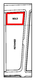
7. Sometimes developers build and sell houses faster than Ordnance Survey is able to survey them. In such instances Land Registry has based its title plans on the developer's transfer plans. As we have seen, at Developer's layout plans on the "Conveyance Deeds and Deed Plans" page, such transfer plans are often a statement of the design intentions rather than a record of what was actually built. Such transfer plans are likely to be particularly misleading as the example further down this page also deomonstrates .
8. The title plan identifies the land in the registered title and it gives only a general indication of the position of the boundaries of that land. In rare cases (and this will be noted on the register) either a boundary agreeement or a registration of the exact line of the boundary will affect the registered title, and it is only via such a boundary agreement or determined boundary that Land Registry is able to tell us the exact position of the boundary.
 |
 |
| Title plan for a modern detached house. Note that the red
edging is placed to the inside of the black general
boundary lines to which it draws attention. Thus
the general boundary runs: (north side) along the back of the roadside footpath; (west) across unmarked open plan front garden, along garage party wall, along fence; (south) along the southern of two parallel features; (east) along a fence, along the flank of the house, across open plan front garden. |
Part of the title plan for the developer's land from
which the land sold off as new houses (including the house at
left) has been excluded. Each excluded land parcel is indicated by green edging, and its title number (blurred in the above example) is also shown in green. To avoid a clash of red and green edging, the green edging is sometimes shown to the outside of the general boundary to which it draws attention. |
| Return to Top of Page |
What the title plan does NOT show
The title plan does NOT show the exact position of the legal boundary nor its relationship to the physical features adopted as the general boundary. Official copies of title plans carry the following warning:
| "This title plan shows the general position of the boundaries: it does not show the exact line of the boundaries. Measurements scaled from this plan may not match measurements between the same points on the ground.". |
The title plan does NOT show the dimensions: in exceptional circumstances a dimension will be reproduced on a title plan, such as the one in the example at paragraph 12 of Land Registry's Land Registry plans: title plan (practice guide 40, supplement 5)
The title plan does NOT normally show T-marks: I have only once seen T-marks on a title plan. Whilst it is not a common practice, I have seen many more examples of title registers that quote a portion of a conveyance deed that refers to T-marks shown on the conveyance plan: there is then a note following the register entry that follows a format such as:
| "NOTE: T-marks affect the eastern and southern boundaries of the land in this title". |
FREQUENTLY ASKED QUESTION |
||
| Boundary definitions: Can I use the
title plan to measure to my boundary from the side of my
house? When I do so I find that the fence is nearer to
my house than the title plan says it should be. Am I right in
thinking that my neighbour must move the fence? |
||
| This is, sadly, a common error. Firstly, Land Registry is not responsible for specifying where the boundary should be: that is the responsibility of the owner who divided the land into its present parcels. It is Land Registry's duty to show only the general position of the boundary. Secondly, the Ordnance Survey map on which the title plan is based is not a perfect representation of the real world (see Using Ordnance Survey maps): scaling distances from it produces misleading results and cannot, legally, identify the boundary’s position. The example of the fictitious Acacia Road, illustrated in the drawing at right, demonstrates that distances scaled from a title plan cannot be relied upon. |
 |
|
The owners of 10 Acacia Road scaled from the title plan a distance of 14 ft feet between the side of their house and the boundary. Outside, they measured with a tape a distance of only 13 feet. Armed with this information they accosted the owner of No 8, telling him that his fence was in the wrong position and that he must re-erect it in accordance with the position of the boundary as shown on the map. Their logic - that "the plan shows the boundary in this position, and the fence is in another position, so the fence is in the wrong place" - can be shown to be false logic if we examine the other flank boundary to No. 10, the one that runs along the party wall that is shared with No. 12, another semi-detached house that is identical to No. 10, but the map shows that No. 12 is 2 ft wider than No. 10. By the same logic that the owner of No. 10 has used to demand the relocation of No. 8's fence, the owner of No. 10 should be offering to relocate the party wall with No. 12 and to give up 1 ft of the space inside his house so that No. 12 can be made up to its "true" width according to the plan. Clearly, the owner of No. 12 would not agree to relocating the party wall. [In case you think that this example is far-fetched, take a very close look at the representation of semi-detached and terraced houses on any Ordnance Survey large scale map.] For another example of a misunderstanding of a title plan, or rather of the Ordnance Survey map on which the title plan is based, see Example of confusion arising from map generalisation on the Using Ordnance Survey maps page. |
||
| Return to Top of Page |
General Boundaries at Road Frontages
The depiction of road frontage boundaries appears
to be a particular problem for Land Registry. With public
highways, the surface of the land is vested in the Highway
Authority (which is usually the County Council) whilst the
adjoining land's boundary might be in the centre of the road.
Land Registry is unable to show that boundary in the centre of
the road because of other interests that may exist in the surface
of the road. So far so good. But Land Registry automatically
assumes that the highway extends to include all footpaths and
verges lying alongside the carriageway of the highway. Sometimes
it does, sometimes it doesn't. In the photo above, the highway authority and the adjoining landowner agree that the boundary between the road (public highway) and the adjoining unregistered land is located at the junction between the footpath and the grass verge. It will be interesting to see where Land Registry places the general boundary when an application for first registration is made. Land Registry's past form suggests that they will place the general boundary on the brick wall. |
||
 |
Update on the above photo and caption: The 1970 conveyance plan is shown at left, and the title plan issued on first registration (in 2010) is shown at right. The green tinted front garden of the conveyance plan abuts a brown tinted private footpath (later adopted as public highway) whilst the title plan shows the part of the green tinted area that falls outside of the wall (which was built in about 1987) as if it is not part of the land in the title. |
 |
| The point to understand here is that Land Registry prefers to place the general boundary along the solid line on the Ordnance Survey map (in this example, the wall) even though it has incontrovertible evidence (the conveyance plan) that the boundary runs along the dashed line on the Ordnance Survey map (in this example, the junction between the paved footpath and the grass verge / shrubbery). | ||
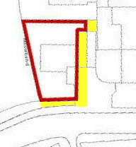 Missing land (yellow) Missing land (yellow)
|
In 2012 the owner of the above property noticed that his garage, driveway and a small part of his rear garden were shown outside of the general boundary on the title plan. He contacted Land Registry with a view to correcting this error and at the same time tackled them on the road frontage issue. Uniquely in this author's experience, Land Registry moved the general boundary from the solid line (wall) onto the dashed line (path - verge junction line). |  Title plan 2012 version Title plan 2012 version
|
The following examples represent the typical treatment of the general boundary at a road frontage. In the example below, the deed plan (left) shows that the building plot numbered '2' extends to the edge of the carriageway. In spite of this, Land Registry has excluded the verge, even though the verge was created at the time the house was built. Land Registry is resisting amending the title plan even though the registered proprietor has received written notice from the Highway Authority that it is not responsible for the verge. |
|
 Deed plan for 'Plot 2' |
 Title plan for the land that was 'Plot 2' |
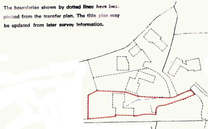
With private roads also, the title plans appear to confuse. Figures 5 and 6 in the Digital Boundaries in Eng& Wales article (see also below) show a private road that runs along the western and northern sides of the land to which the two illustrations relate. The property boundary is clearly located in the centre of the road but the title plan shows the general boundary along the fence line. In practice the private road comprises a narrow carriageway between broad grass verges, and the local residents have formed a road fund committee charged with keeping the carriageway in good repair. Land Registry would have been unaware of the existence of the road fund committee, and that committee in any case holds no legal interest in the private road. So there would seem to be little justification for Land Registry to show the general boundaries at the edge of the private road rather than in its centre. |
 Photocopy of HMLR filed plan for a property |
 Extract from a conveyance to the same property |
|
In the example below, there is clearly a line on the Ordnance Survey map that better reflects the position of the boundary than the line chosen by Land Registry to represent the general boundary. This is again a private road and the circumstances make it clear that the carriageway of the private road is in separate ownership from the verges on either side. |
|
 Conveyance plan: note that the northern boundary of the property encloses the verge on the south side of the road |
 Land Registry title plan of the same property: note that the southern verge of the road is shown outside of the general boundary. |
|
The obvious inference of the preceding examples is that you should assume that Land Registry's general boundary at the road frontage is shown in a position that differs from the true position of the boundary. |
|
| Return to Top of Page |
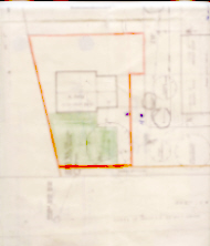
Case history - Title plan misleads when based on design plan
| Let us return to the example of Developer's layout plans on the "Conveyance Deeds and Deed Plans" page. This is one of those examples where new properties were built, sold and registered before Ordnance Survey was able to put them on their map. Land Registry was forced to base the title plans on the transfer plans. As we have already seen, these transfer plans were based on design plans and do not represent what was actually built. Below is an extract from the title plan for one of those properties. | |
|
|
Based upon the above title plan, I have created a number of coloured polygons,
each colour representing the land within a separate title as defined by the
general boundary. Onto these coloured polygons I have overlaid my own survey of
what was actually built on the ground.
|

|
| Be very wary of title plans that are based on design plans: the general boundaries are very likely to be located in some other position than the true position of the boundary. | |
| Return to Top of Page |
Case history - transfer plan misleads Land Registry
It is Land Registry's practice when creating a new title plan to attempt - as a desk exercise - to reconcile to the Ordnance Survey map the information submitted with an application for first registration. Only if they encounter a complication will they send someone out to site to resolve the complication.
The case that is illustrated at Example of a General Boundary on the "Understanding General Boundaries" page demonstrates how an inaccurate title plan can result when a transfer plan is taken at face value with no ground check as to whether it reflects what is actually on the ground.
It also demonstrates the misunderstanding to which landowners can fall prey when they place too much reliance on the general boundary shown on an inaccurate title plan.
 |
As a reminder of what happened in that case, one
company owned a parcel of land stretching along the west side of
one road, all the way from one road junction to the next road
junction. That company decided to split its land into two, and
marked the division between the two with a fence. When the smaller, northern part of the land was sold, a transfer plan was drawn up. The transfer plan was based on an Ordnance Survey map, but the fence was not shown on the Ordnance Survey map and the vendor mistakenly used a map grid line to represent the southern boundary of the land that was being sold. |
 |
| When drawing the title plan, Land Registry took
the information it was given and placed the general boundary
along the grid line. The general boundary does not represent the
true line of the boundary, which of course follows the line of
the fence. This case illustrates two points: 1. Vendors (or perhaps the professionals working for them) sometimes demonstrate incompetence when describing the boundaries of a parcel of land in a legal document; 2. Land Registry's practices do not always identify those erroneous boundary descriptions - that require on site investigation - in the deeds submitted to them for first registration of title, with the result that title plans sometimes perpetuate the errors. |
||
Hopefully this page has convinced the reader that:
Land Registry title plans do not show the
exact line of the boundary.
The reader should also be aware that
Land Registry is NOT responsible for defining
property boundaries.
Links to Land Registry's web site
HM Land Registry Blog
See all of Land Registry's blog posts since 24 Feb 2014.
LR Blog: Drawing the line on boundaries
HM Land Registry plans: practice guides
This series brings together all HM Land Registry guides relating to plans.
| Return to Top of Page |